
LandSearch switched from Mapbox to Stadia Maps for satellite imagery, resulting in high-quality images at a lower cost.
Summary
LandSearch is a land and lifestyle real estate marketplace covering hundreds of thousands of listings across millions of acres for sale or lease. Launched in March 2020, the website receives millions of visits per month from buyers looking for farmland, hunting ground, homesteads, cabins, tiny homes, and raw acreage.
After scaling with Mapbox, mapping became one of LandSearch's largest application expenses. For a short time, LandSearch served satellite tiles from Amazon Location Service, until they decided to switch to Stadia Maps for its high-quality satellite imagery and responsive customer support.
Highlights
- Satellite imagery sometimes serves as the listing photo for rural properties on landsearch.com, making image quality a direct part of the buyer's first impression
- Left Mapbox to save thousands of dollars per month and avoid annual commitments
- Chose Stadia Maps for image quality described as consistently better than Amazon Location Service at comparable costs
- Access to the Stadia Maps team without a paid support tier
- Stadia Maps' Isochrone API is being considered next, powering drive-time search for buyers who care about how long drives take between properties and places
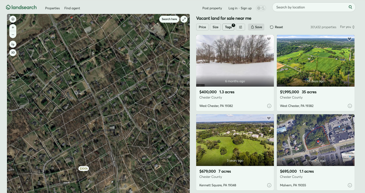
LandSearch shows Stadia Maps satellite imagery under its own parcel tiles.
Land Is Different Than Residential Real Estate
Michael Leigeber co-founded and later exited a digital marketing agency. One of his clients was a large land brokerage, which gave him a front-row seat to the marketplaces serving it. "Real estate marketplaces in general have been behind the curve in terms of UX and innovation," he says. "It felt like there was an opening to do better."
So he launched LandSearch, which curates land into four types: agricultural, commercial, recreational, and residential, because inventory behaves differently in each. In addition, Zillow, a popular American online real estate marketplace, doesn't show many commercial properties, and agricultural listings are often absent from the Multiple Listing Service (MLS), the backbone of real estate in America.
LandSearch represents the listings of tens of thousands of agents, alongside a large for-sale-by-owner base, and is monetized through advertising and subscriptions. "Part of being a land marketplace is trying to pull together disparate inventory and get all of it normalized into one platform," Michael says.
Users differ as much as the inventory. A farmer expanding an operation, someone looking for hunting property, and a buyer planning to place a mobile home are three different searches, each with a different definition of a good result.
Why Satellite Imagery Is Not Optional
For most real estate products, satellite view is a toggle. LandSearch doesn't work without it.
Past a certain zoom level, a LandSearch map automatically switches to satellite view. The reason is that vector data stops answering the questions land buyers actually have. "You get to a certain point where users want to actually see how dense the land is," he explains. "Is there development nearby? What does access look like? You learn a lot about the property looking at satellite imagery."
Paired with parcel data that LandSearch bakes into its own tiles, the picture gets even more specific. Where do improvements sit on the lot? Are they set back from the road, or 10 feet from the nearest neighbor? What is the topography? Buyers can also toggle between alternate satellite sources because imagery is often captured in different seasons and years.
On remote land, it's often not economical for anyone to go take photos. When a listing arrives with no cover image, LandSearch uses satellite imagery as the preview in search results. "It's invaluable," Michael says. "I can't imagine not having the satellite component, because if you just have vector tiles all the way, and that's kind of where you stop, you've lost even the high-level basics like whether the property is wooded or cleared."
Michael is careful not to claim a clean attribution line from LandSearch's satellite imagery spend to business outcomes, and says building that correlation would be difficult. The consequence is more direct: for a meaningful share of inventory, satellite imagery is the only visual available for a listing. And with 75% of landsearch.com traffic on mobile, that imagery has to load fast.
The Transition from Mapbox
LandSearch came to Stadia Maps from Mapbox, and Michael tells that story with credit rather than complaint. He used Mapbox at his marketing agency and found them easy to work with. Two things changed at LandSearch.
The first was the billing structure. Mapbox counts a map load each time Mapbox GL JS initializes, which resulted in additional expense and engineering to optimize against. "We're popping up maps all over the place," Michael explains. "You may have a map behind a modal that has another map in it, so you end up creating multiple sessions for one user."
Mapping grew into roughly the company's second-largest single vendor expense, with, in Michael's words, "no end in sight." So LandSearch went looking for volume pricing but came away disappointed with the options.
The second was support. "As a small customer, we just couldn't get attention," Michael says. Not implementation hand-holding, which LandSearch doesn't need, but bugs. "It could take months to get a resolution."
A Detour Through Another Vendor
LandSearch already ran significant infrastructure on AWS, so Amazon Location Service was the natural next stop. That didn't work for them either.
"It really just came down to quality," Michael admits. "In major urban areas, everybody seemed to have, give or take, good resolution. But where Stadia Maps really stands out is the consistent quality, especially as you get more rural."
Rural is not an edge case for LandSearch. It is a large part of the business. "We could just count on a much higher average quality across the United States than we could with Amazon map tiles."
Support also reared its head again. With Amazon, "unless you have an expensive support contract, you kind of have to pay to report bugs, let alone actually get help with something," Michael says. With Stadia Maps, "when we reach out, we get answers."
Build or Buy?
LandSearch runs a distributed infrastructure, building their own tiles using PMTiles and serving them through CloudFront, drawing on Overture and other open data.
That is also the reason LandSearch doesn't use vector tiles from Stadia Maps. "We have a few different datasets that are unique to us, and we could show them in a different layer, but if we're going to be serving those tiles anyway, it makes sense to build it all out on our end and serve it together."
There aren't many real estate marketplaces at LandSearch's scale, and they keep their data close. Once you go beyond localities and postal codes into parcels and properties, the datasets become proprietary. So LandSearch builds there.
Satellite imagery sits firmly on the buy side. It is expensive to source, expensive to keep fresh, and no part of it is proprietary to LandSearch. "With enough money, you can license whatever you want," Michael says. "But there aren't many pay-as-you-go options out there."
What's Next: Drive Times and an Ongoing Partnership
Since launching in 2020, LandSearch has delivered more than a million leads, giving the team a clear view of what its customer base needs. Much of what buyers ask about is proximity, and not to an address but to a category of place, like a grocery store or a hospital.
The next problem LandSearch wants to solve is land-specific accessibility. "Let's say that you want to live outside of town. Drive time may be more important than miles," Michael explains. "Something can look deceivingly close to town, but it's a long, winding, slow road to get there."
The plan is to let buyers search by commute time and to show nearby points of interest on the property detail page. "For the drive time, we would likely use the Stadia Maps Isochrone API to build out that geometry," Michael says.
LandSearch and Stadia Maps continue to grow together, and Michael's default recommendation has changed. "Anytime that I run across somebody that needs mapping at scale, I recommend Stadia Maps," he says. The reason is not a feature list. "I email Stadia Maps and get answers from their team. They've also been responsive to the feedback that I have," Michael says. "I've been very happy with how Stadia Maps has evolved with us and matured as a company."
Frequently Asked Questions
Who is LandSearch?
LandSearch is a leading land and lifestyle real estate marketplace. Listings include homes with land, commercial lots, farmland, recreational acreage, and more.
Who is Stadia Maps?
Stadia Maps provides APIs for maps, geocoding, search, routing, and navigation for developers building location-based applications. The platform is privacy-first: no tracking, no telemetry requirements, and GDPR- and CCPA-compliant by default. Pricing is credit-based, usage-driven, with no hidden multipliers for active users. LandSearch has worked with Stadia Maps since 2024.
What is satellite imagery resolution?
Satellite imagery resolution is the ground distance represented by a single pixel in an image. It is usually written in centimeters or meters, so 30cm resolution means one pixel covers a 30cm by 30cm square of ground. Lower numbers mean finer detail.
Why does satellite imagery quality matter for land listings?
Because on remote land, photography is often not feasible, the satellite tile becomes the only image of the property and serves as the listing preview. It's also how buyers answer questions vector data cannot: tree cover, topography, density, what sits on neighboring parcels, and where improvements actually sit on the lot. Stadia Maps satellite imagery offers 1.5m or better resolution globally, 50cm across most of North America and Europe, zoom 18 global coverage, and an area-weighted average image age of about 1.6 years.
Can a small team use satellite imagery without an enterprise contract?
Yes. Stadia Maps provides satellite tiles on the same credit-based, pay-as-you-go pricing model as its other APIs, with no enterprise minimum and no annual commitment required to get list pricing.